2015. március 21.

100 SOTA activation

So I finally arrived to this magic number. After almost 5 years of hiking to summits with some radio gear, today had the chance to reach a first psychological limit that will now make me think on closing in on MG, a goal which seemed very very far far away back in 2010 when I first put my foot on summit (and came back without any points because the lack of interest in the activity back then).
I had this one planning the whole week, I even invited a bunch of people to join me, and the plan was to make it more interesting to go to YO/EC-145 starting from Azuga, then descend to Predeal and it time permits climb to YO/EC-241 to reach the 100th activation. I bagged both summits last year (or a year and month) so they are not new, it was just the long hiking route that made it a real nice crowning of the day.
I will not describe the route as detailed now, as I had done so already after my previous activations, I just want to share some photos taken along my hike.
An yes it was my hike, as it turned out that even though I was expecting a few guys joining me, it turned out that they might have got scared from the 1cm fresh snow that fell the day before, or just couldn't get up at that early hour. Yes it was indeed early, as planning a longer route I decided on taking a train to Azuga, and the only one suitable was leaving Brassó at 6:20 in the morning. My friends just can't get up that early. Barely could myself, but at least I had in my mind the possibility of the centennial activation, so I was at the station still in the dark, and a bit disappointed by the completely overcast sky.
Fortunately by the time I reached Azuga the clouds started moving around giving hope of improving weather. Opposed to last time, I was taking the more direct approach to the summit, the trail marked with blue triangle starting just a couple of hundred meters from Azuga train station. This trail goes up to the summit, along the ridge and down to Predeál, exactly the route I had in my mind, so it was a natural choice. And the trail marking is excellent, it was very easy to follow even with the fresh snow layer from the day before.

So I set out in solo, treading the snow with no other footprints (well this was expected after the yesterday snowing and the early hour). Soon after I started the sun finally break through the clouds, enforcing once again my expectation of good weather for today.
It even started coloring the forest with spectacular morning light, really encouraging on the long hike up:
Finally a bit more after and hour of hiking I started to see the light at the end of the tunnel (tree tunnel that is)
But of course that is misleading as there is still some more climbing out in the clear. To make it worse out of the tree cover, where the winds have their word, the snow got ticker and needed some serious breaking in
But as the sky started to clear up, it was well worth it, the amazing panorama around compensated for the tiresome advance.
The Bucsecs mountains in their morning beauty make just the perfect scene to admire the whole day

Except when it is freezing out there. And unfortunately it was. I was just a bit too early on the summit (one and half hour hike instead of the expected 2 hours), but still too early anyway, and it was very very cold. The sun was getting out of the clouds, but I recon it still needed an hour to warm up the weather to a pleasant atmosphere.
So in full clothes, with everything on me, I built up the station and started calling. Not to many takers this early, but fortunate enough for 2 s2s contacts. And afraid it was just to early for VK, I was really hoping to catch an LP window, but again I think I should have come an hour later. It would have been much warmer and probably in time for the window.
But that was it after about an hour of stay on top, I was really started freezing, so I went QRT, and after a few more photos of the panorama and the way in front of me, I started the descent towards the Gârbova hut
where a nice hot chocolate brought me back to life. From there another climb followed up to the Clăbucet Plecare (the high point of the Predeal ski slopes). On the way up I had this insight to just look back a bit to the hut, and it was quite an amazing view with the summit from where I came behind the hut, and my solo trails down on it, nothing else was seen in the fresh snow.
Another half and hour of climb followed until the top with some remnant of some unfinished plans to ruin the untouched nature
 This is also the point where the ski-lift from Predeal and 3 slopes start from here.
The blue triangle follows the western slope (also marked with a red 1) which is quite steep, making a not too easy descent
so I was glad that the trail at point break off the slope and went into the forest, having only a narrow path.
Well my joy went away quickly as I realized that below the fresh snow actually the path was one continuous ice block smooth as a glass. Probably the most terrible descent of the day. This is definitely a no go in winter conditions.
I was really glad when back at ski slope finally had an outstanding view over Predeal.
 From there in no time I was down in the city, and already could take a look on my next destination, YO/EC-241 and my number 100
But until then another 3 km of boring city walk until the another end of Predeal, before I could set foot on the trail marked with blue cross.
Well isn't that a different scene from last year? And my last year activation was about the same time of the year. And still then it was everything dry, in flowers, warm, and now it is plain snow. Ok the temperature was not bad this time either, since leaving YO/EC-145 it did steadily rise, so when I arrived to the summit it was quite comfortable, so I could easily had all the time to work all the chasers.
This time I erected the antenna right in the middle of the summit, which I avoided last time because all the motorcycles crossing by, well now it wasn't any danger of that and the snow was the same everywhere
At least I didn't needed all the pieces of cloth this time so I could made a nice place to sit down.
This time a much bigger pileup awakened when I spot myself (regarding this my spot first went out with the reference of last weeks summit, that was strange from the spotting app, but quickly rectified it, I hope it did not cause too much confusion).
I stayed until the pileup completely went away and even after that gave enough time of CQ-ing for any late comers. Much better weather than in the morning.
Still after silence for a while, and when the colors of the forest started to mimic the one from the morning
I decided it was time to leave the summit behind (and also the Sun already on the other side, but still shining through just as in the morning.
Another half an hour of descent until the Predeal train station, and with my luck a train just pulled in exactly the same time. Just exactly to by a ticket and get on it. So I did actually get home much earlier (still in the daylight) then on my previous outings.
Oh, and as I usually give the track for the summits (but already have given for these from the last time), I just put here the whole route for today
A total of 18km hiking, with 1200m total ascent and a little less than 9 hour for it. Quite nice, again something I wouldn't dream of when I first went on a SOTA activation.

So thanks again to all the chaser from this 100 time, and let's meet on the waves for the next 100 and many many more.

2015. március 15.

YO/EC-328 and YO/EC-325

Yesterday another hiking day for our usual team, Sorin, Barbu, Mihai and me went looking for some hills in the area. Weather forecast was not too optimistic so we decided on some smaller hills near the Buzău (Bodza) valley, YO/EC-328 and YO/EC-328.
For the first one the choice fell on YO/EC-328 as it is closer to the main road, and we were also expecting a good portion we can get by car on a forest road which showed up on our map. Well we couldn't be more wrong as we were not counting that the snow was still melting down in the darker valleys and the road  was just a sea of mud:
So we had to ditch the car and go on by foot which wasn't very thrilling either, so at the first opportunity we entered the woods on the basis that is much more pleasant to walk in the autumnish looking forest (not too much sign of spring yet)

An easy hike follows in the forest, rather gently slope to climb, a young oak forest and also opposed to every forecast an excellent weather shared our journey.

The summit is at the end of a bit long ridge, and unfortunately on one side and entire slope was cut down, with the bush barely getting over it, which on the other hand proved an excellent shack with a good view to the south-west. A long-long time since I had such a comfortable sitting on a summit:

While I was activating, the friends found a slope on the northern side of the summit (not visible from my point) with still a good thick snow, so they went on skiing over there. A long run of QSOs for me with a big pileup at the beginning and a couple of nice s2s at the end. When everything went quiet and the guys finished skiing was time to get back to the car to catch the next summit before sunset.

The summit YO/EC-325 is further away from the main road, but we found a very good forest road starting from Zăbrătău (Zabrató) village along the creek with the same name, which although was muddy, but still better than the previous one, so we were fortunate enough to ride along the 10km road up to the base of the summit. We left the car were the main road takes a U turn and two auxiliary road coming from each side of our summit intersects it. The lesser roads were a mess anyway, so it was time to hike again.
This time wasn't fun however, a very steep slope awaits, about 300m elevation gain on less then 1km distance, and also except for some tree-cutting trails at the beginning we had to go in a very thick pine forest
On the first half of the hike we could barely see 3 or 4 trees ahead. Later on the forest got a little bit thinner and also some snow appeared
Still it took us slightly above 1 hour to reach the summit (not really spectacular achievement for 1km hike. The summit was much more enjoyable however, with a quite nice glade around, and on the other side we could also have a good panorama. The shack was not as comfortable as the previous one, but still quite up if I were ever to construct a ranking for this.
The pileup was somewhat smaller this time, and also some contest QRM kicked in, so quite soon I was out, but being also later than we initially anticipated, that was it for today. The way back was almost as hard as coming up, going down in that thick forest on a steep slope is very tiresome, so we were glad to be back to the car still in the daylight (and get back to the main road before dark).

Probably there is a better way up to the summit going along one of the forest roads cycling around it and climbing up to the large glade behind the summit, and only a small portion in the forest, but that is longer hike, and only advisable if enough daylight is left for it.
Anyway here is the track for the 2 summits, blue marks the trail of the first hike and I would highly recommend it, as even if not on road, it is very enjoyable, the red and green marks the trail for the second one, with red being the road took by car which is also easy to do even in small cars if the weather is dry enough (after rains or in winter-spring condition it can become very muddy), from there however I would only recommend the direct approach we took only to the real adventurous ones, probably there are better ways around it

2015. február 22.

YO/EC-263

After yesterday good weather (except for that crazy wind), today started to gather some really nasty clouds on the sky, and forecast started everything from bad to worse for the next couple of weeks, I decided to do one more close summit before the rain season comes in which probably will hinder my activation attempts for a while (if the prognosis is right which of course we know that is only a probability game, and well I just have to keep some optimism).
Anyway as the closest summit I managed to activate last Sunday, the next closest one, YO/EC-263, Kőmöge came into picture. This is the highest summit of the Bodok mountains, the central mountain range in Háromszék county, with the altitude of 1240m, so a good a 6 pointer with about 4.5km of hike needed from the main road.
The summit is situated in the northern part of the Bodok mountains, with the easiest approach from the Best Western Bálványos hotel on the middle of the road connecting Kézdivásárhely with Bükszád village on the the Olt valley. The hotel was built right at the saddle point between the Bodok and Csomád mountains, and also the highest point of the road crossing between the two.
There is a large area at the pass, where the car can be left and the hiking trail starts right from that parking just face to face with the hotel. The trail is well marked with yellow stripe, and it was easy to follow even with the tracks completely covered with snow due to the markings on the trees.
This photo was taken looking back, those are my footsteps. Unfortunately there were absolutely no human trails in the snow before just some occasional animal trails, some small ones and few wild boars, so I had to break my way through the snow. Most of the time that wasn't too big issue, however there were ridge portions with probably some crosswinds where much more snow accumulated and a couple of time I sinking pretty deep into the snow.
The track starts with a quick climb and after that a very long gently rising slope, after which a very tough, very steep climb follows and keeps up pretty much.
After a lot of walking and some more steep climbs finally I was seeing a bump in front of me:
but then I looked at the map and become rather clear that this is not it. Actually if you look it better, on the first tree there is an arrow, and that one indicates, that the yellow stripe take a right turn going down instead of climbing to that bump. And it goes down quite a while just to turn into an even bigger climb. And a few more time it repeats the scenario, always when you think that the bump in front of you is the summit, you arrive to the top of it, just to notice that from there you go down and further away there is an even bigger bump waiting.
So after more than 1.5 hours of breaking snow and throwing lungs out, when you are already in the state of just going ahead like a zombie, finally you can see a bump which is still not the summit, but from where the true summit is already visible:
So a few more zombie steps and you are at the summit, marked with a pile of stones with the altitude of the summit (1240) written onto them. Actually that state of zombie is not that bad in the area, because it chases away the animals, and now I'm thinking of the wild boars which seem to like the summit area, trampled completely.
This time was quiet however, so I quickly set up the antenna, there is forest around (oak on one side, pine on the other, rather interesting), but there is quite large space around for all types of antennas,
and a quick check on the Sotawatch (very good mobile data signal on the summit) to look out for some s2s, and first to see is EC2AG/P again out on some newly added EA2 summit with a huge pileup. Took me a while to break through but finally got it, and after that with a self-spot I started the usual mayhem for myself also. This is getting pretty standard now, so jump ahead to the part with the pileup dying out and collecting the station. I was staying out a bit longer than on previous times, but the cold started to bite so again I wasn't completely exhausting all the possibilities (especially with some hunting on other bands). I'm ever more eager to have some good summer activations with very long stay on the summit.
The way back down is much quicker with almost like sliding down the hill, but still took quite a while (more than an hour) and started to get again into that just go and go and go feeling until finally I was able to see the hotel building between the trees

Well these photos of winter activation in mid-forests without any sight or panorama out of it starts to get boring, so better here some nice vivid colors of the tracklog to the summit

Just one more note, I think that this summit is better worth activating in the summer period, as based on the terrain and trail markings it is possible to get there with a bike, with very few fallen trees and obstacles, and a lot of wide space between the trees. Now I don't know the actual state of the track under the snow, but definitely worth checking out.

A longer version for activating YO/MC-031

Yesterday I joined the EKE on their usual hike to the Törcsvári Magura (Măgura Branului), nice SOTA summit, been there already a couple of times.
What was different this time was the snow conditions and the longer hike all along the ridge (until now I had activated it by either hiking from Törcsvár or from Măgura with going back the same route), so a much longer but no less pleasant hiking.
Too bad for the heavy wind. I couldn't even manage to keep the antenna in a vertical position, but was good enough for a small pileup. And of course best contact of the day a summit to summit with Petronel, YO8SEP/P activating Nagy-Hagymás (I also intend to go there next weekend).
Still experimenting with Picasa, so photos of the hike over to G+


But here is the tracklog for anyone interested, about 15km hike, with a few steep portions but overall a very nice hike with splendid panorama.

2015. február 15.

A weekend of snow and sunshine

Excellent weather forecasts for the weekend also meant SOTA activation. Based on the weather in the city and no trail of snow left in there I was expecting also in the lower regions the snow already melted so was going for some summits in the old Miklósvárszék. Of course I coulnd't be more wrong but a bit later about this.
This time only YO6HXO joined so we set out early in the morning towards north. I was looking at YO/EC-374 and YO/EC-413, two smaller hills (in the range of 900m) facing each other on the two sides of the Olt river. EC-374 (Fekete-hegy) is a bit higher and also the closer to Brassó, so it was our first destination.
For starting point a good option is the village of Ürmös (Ormeniș). Actually there are some forest roads branching off the main road just before the the village which probably could take us closer to the summit, as we approached the area we had to realize that I was too optimistic about the snow conditions and even if next to the road it was indeed melted, a bit higher it was still present and the forest roads didn't really promised a good opportunity to safely get back from them without sinking somewhere in the middle.
So we left the car in the center of the village and set out on foot to conquer the village. This meant a hike of about 6km to the summit with about the first 4km out in the plains (well actually more like highlands, there was a bit climbing just at the exit of the village, but after that a long and flat hike (with a lot of snow):
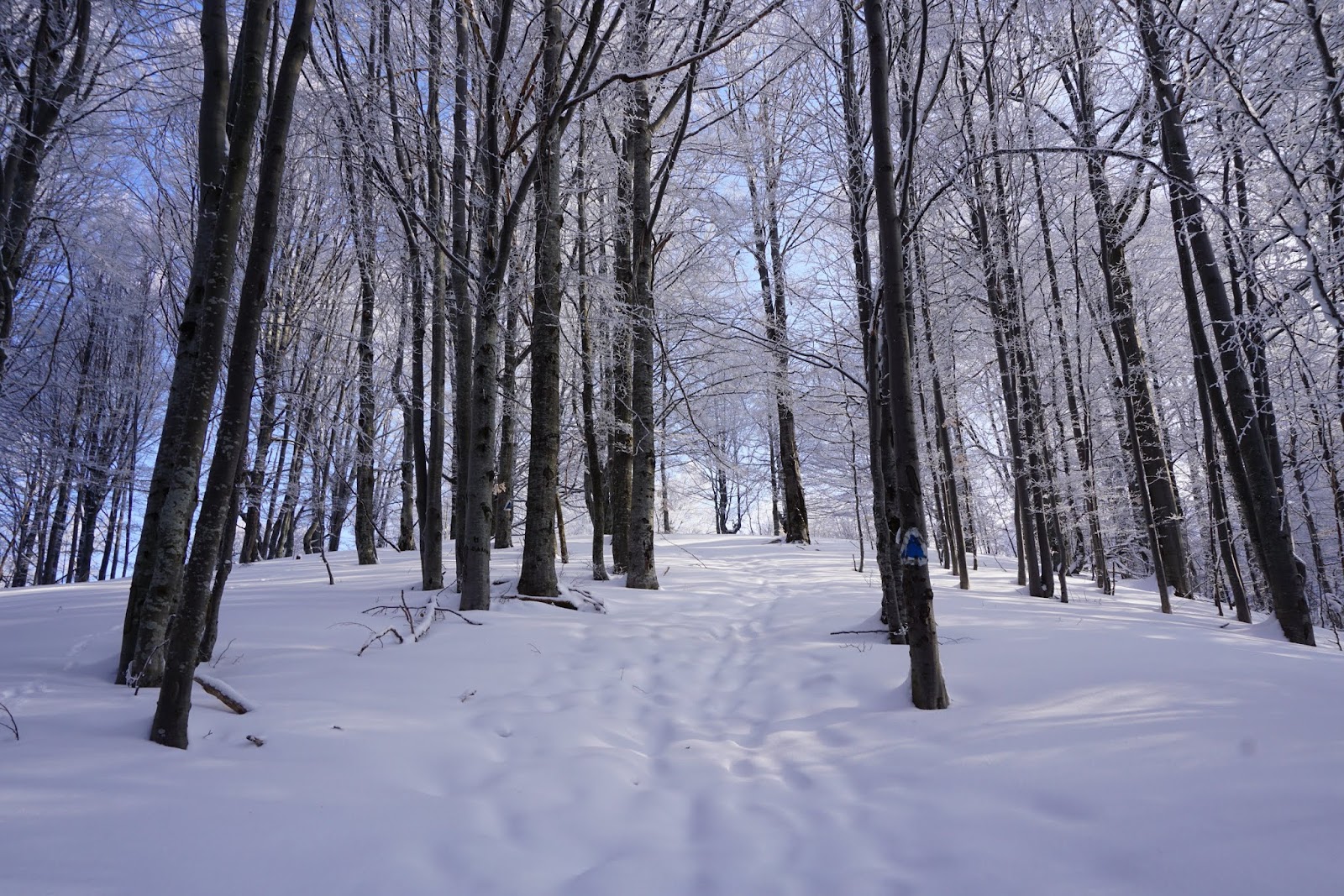
Setting forth for YO/EC-374 (the high point in the middle)
Yeah it is quite boring just going and going, and the mountains looking ever further away, but eventually we got into the forest and wasn't even that late:
Early sunshine in the woods
The problem was that the road we were following (and a very good road) started to act like a labyrinth just after entering the forest, with many crossroads and turns (it just seemed to be a portion of recently planted woods with a somewhat regular net of roads) but they were not really circulated in the winter, only a couple of them having tracks. Having no idea which one is the good one, we followed the one which had the most tracks. This turned out to be not the optimal solution as the road ended quite abruptly in a valley with some fallen trees closing the way and all the tracks just turned back at that point. We definitely found the spot where the locals were gathering wood, but that was much down from the summit.
Having nothing else to do, just took the most direct approach upwards following the steepest ridge:
Nice clean ridgeline
Obviously no trails whatsoever in the area (except for the occasional animal footsteps, but only minor ones), but fortunately the snow wasn't that big either so it was a bit breaking but slowly we were gaining altitude. Eventually we came across another road coming from the right which turned out to be the one which we should have taken from down and it really took us up to the summit.
Steep climb, and the summit is still quite a bit upwards
About 20cm of snow welcomed as at the summit, with the summit stone rising out of it and also a small glade perfect to erect the antenna
Of course I always forget to take photos of the antenna and the station after setting it up, but I'm just to eager to get down to business and sink into the pileup. And there was pileup, I could manage to get some weak data signal enough to spot myself, which of course instantly brings in a flood of callsign fragments and bits of human voice from which I always trying hard to catch one or two letters. Well this is the fun part anyway and the SOTA community is very gentlemanish in this regards.
The pileup went quiet after about a half an hour including DL1DVE/P breaking through it for a nice s2s. After the band went quiet I also decided to get going for the next summit, not before checking out for other possible s2s, so after some trying (and this time on the wrong end of the pileup for my QRP signal) managed a contact also with EC2AG/P. With nothing else for me to hear, we brought down the station, and headed back down the road. This time we followed the road down all the way also finding the place where we should have made the right turn. Next time I'll be careful on that (tracklog at the end of this post).
Going down was much easier, but then out in the open the same boring flat walk, this time with our next target in front of us. This helped a bit, so a little over 4 hours after leaving the car we were back to it.
Next target was YO/EC-413, Bükkfej with the starting point at the village of Köpec (Căpeni). To get there however the Olt must be crossed and the closest bridge is in Ágostonfalva, the next village to the north. To our surprise it turned out that the national road on which we came up till now and which continues to Ágostonfalva actually turns into an unpaved dirt road at the exit from Ürmös and keeps that way a few kilometers. No other choice, we had to follow it, a bit muddy, but overall not that bad. Before entering Ágostonfalva again the road become paved, and no other surprise followed until Köpec (except maybe that from this point on the asphalt was in remarkably good shape especially for this region of the country).
Again stopped at the center of the village, and from here a very good marked trail (red triangle) goes up to the summit. Actually there are couple of marked trails to the summit from all neighboring villages, but I think Köpec is the closest one.
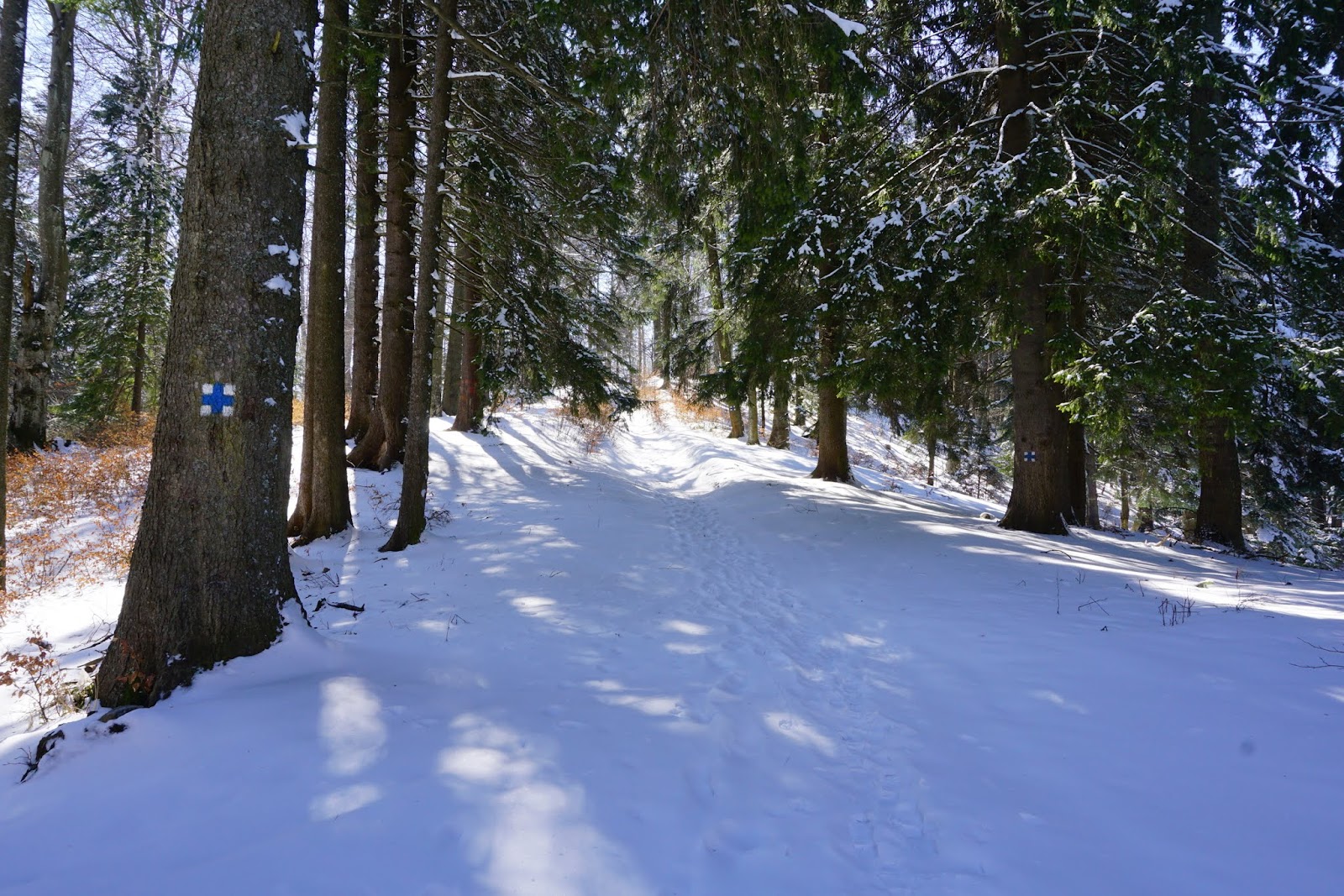
Again there is a couple of kilometers in the plains before entering the forest and starting the climb on a very large and apparently circulated forest road:
Some fresh tracks in the snow
Another two kilometers of hiking in the woods following the trail, except for a small portion where we decided on a shortcut, because it took us on clean snow, while the road was quite muddy, and we were up on the plateau which is quite large and completely bare. On the other hand it offers freat panorama around.
Breaking a track to the highest point of the plateau
Right were the highest point is are some remnants of some trenches from the World War, and a good place to sit down and build a nice shack.
Digging into the snow
This time much better mobile signal, so I could start right away with a summit to summit, (ok, with a little patience and trying), and after that the same big pileup. Not to forget, thanks all the chasers contacting me on either or both summits.
While the pileup was going down the same was true for the sun also, so not long on the summit we gathered again to get back down before dark.
View to the west
Same route back down, we got out of the forest to catch the sun hovering right over our morning summit an to admire a wonderful perspective of the hills we were hiking to
from this point on the sun quickly fell beyond the mountains
leaving us just enough time to get back to the car in the twilight

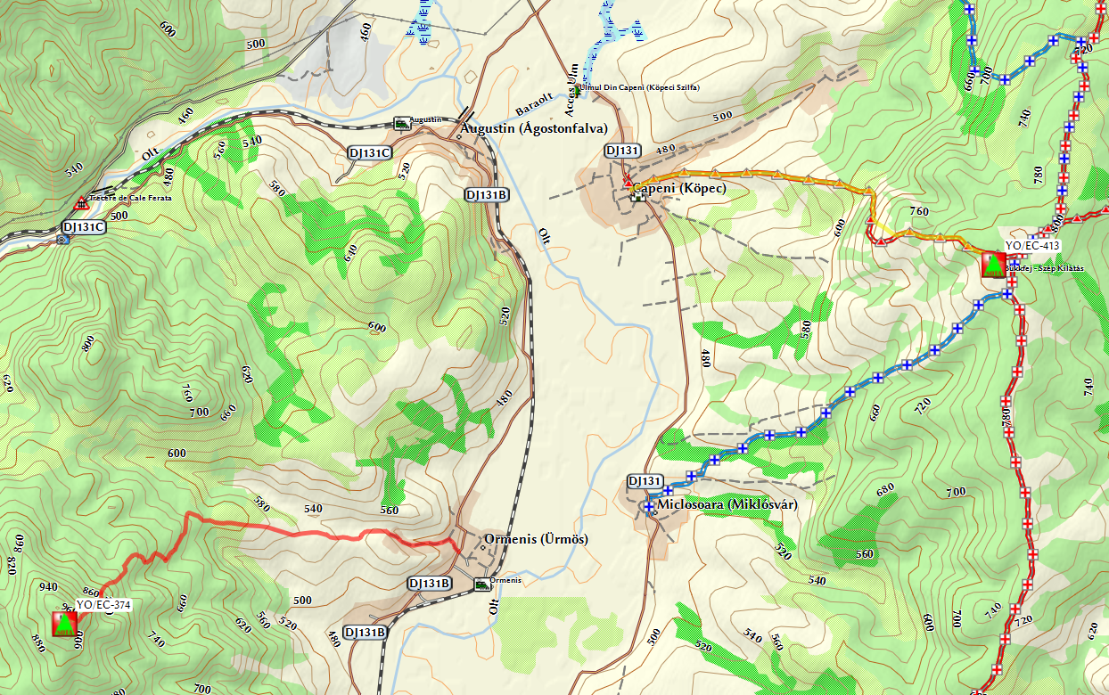
And of course here is the track of the two hikes, red is the first, yellow is the second one (this latter is superimposed on the red triangle trail, so maybe not as easy to see, but at least at one point where we made a shortcut it gets away from the trail):

Well, this is the end of story, or maybe not, as the excellent weather kept on for Sunday also, so there was no way I can postpone any more activating YO/EC-477, Fej, the closest summit to my home QTH, which was already growing on me on why left unactivated for so long.
The sun was shining and this time by myself only I set out to the summit. Based on mapping two approaches are apparent to this summit, one from Szárazpatak and the other one from Katrosa. The former is probably the most used road by local shepherds so good easy trail, while the latter is the shorter one but also more steeper. However learnt from yesterday experience I was expecting a lot of snow, and of course this time of the year shepherds don't go up the mountain, so I decided for the Katrosa route, to have a shorter path to break through the snow.
The trail starts with a forest road to the left from the main road, just before the large bridge at the entry to Katrosa and follows the creek for about 3km, after which a big clearing to the left shows the steep wall that has to be climbed to the summit.
Along the road in the valley there were some tracks (probably from woodcutters) so it was an easy go, but after leaving the creek no more track. From satellite imagery the trail should be obvious, however everything was covered with snow, so I started following a clearing in the forest what looked almost like a road
Small road in the forest, no trails whatsoever
This turned out be a not wise decision as soon it was imminent that I'm on the wrong foothill, covered with woods instead of the clear one seen on the satellite.
Also the road I was following vanished quite abruptly, so I was there in the middle of the forest, with somewhat deep forest and very steep climb in front of me. However going back down and taking the good path wasn't pretty attractive either, so I continued going upwards on a unending climb in the snow slaloming around the trees.
Finally I saw the light ahead of me, as I arrived to the bare plateau, with about 800m away from the summit. Absolutely no trails whatsoever, only snow everywhere I could see, but still an easy hike after the climbing. Oh and a nice panorama to the Háromszék basin
My tracks snacking on the plateau
Quick setup of the radio followed, again digging into the snow, but I'm already getting used to, and as turn on the radio I hear SV3GLI/P calling CQ SOTA, it took some time to break his pileup, but in the end a good start with s2s contact. And to be better after checking Sotawatch (good mobile net signal on the summit) run into GW6WRW/P for another s2s. After that a selfspot and the usual pileup for me as well. Another highlight was DB7MM/P breaking through my pileup for the third s2s.
After the pileup dying out and bringing down the station, I was heading this time the correct route intended from start, which was quite clear where to descend from the summit
Descend from YO/EC-477
This route is much easier (especially downhill, less then 20 minutes I was down to the creek), so I just put here the tracklog of this route, it is also a good approach for climbing in the summer, as except for the 100m portion at the base it is clear of the woods.

That's about it, wonderful and tiring weekend, overall a big fun.