2014. szeptember 8.

A weekend in the Căpățână mountains

This time we had a full weekend of hiking in the south, near Horezu city with some small hills and big mountains. The idea came from Mihai, YO6HXO, to visit his uncle living in a small village near Horezu, and couple it with some hiking in the Buila-Vânturarița National Park and the Căpățânii mountains.
So we left early from work friday afternoon to take a 4 hour drive through the valley of the Olt and then in the Sub-Carpathians
In the way we stopped to admire the trovants, these strange rock formations which have a dedicated museum in Costești:
and of course to take some photos of them
If your are wondering what Mihai was photographing, well here it is:
Little flower inside a big rock
Anyway after a lot of driving and admiring places it was time for some SOTA fun as we arrived to the edge of the Buila-Vânturarița National Park. Of course there was plans for visiting it more thoroughly in the weekend, but for starters we had this smaller rock on the southern side called Arnota which is quite easily accessible, taking a right turn in Costești and then through Bistrița, finally going by the quarry on an impressively good service road, which after the quarry it even turns into an asphalt road leading to Arnota monastery. From the monastery comes the hiking part, about 1 hour to the summit, mostly because the track is quite non-existent, we did find from time to time some old markings but not enough to follow them so we had to find our road. The fog wasn't helping either
and of course it hindered our attempts to make good photos.
But at least here is the track from the monastery to the summit:
As you can see we didn't really managed to find the hiking trail (the red line on the map) even though it was also on the map, but nevertheless the terrain is quite simple, and we even managed to get down without a hitch in the dark.

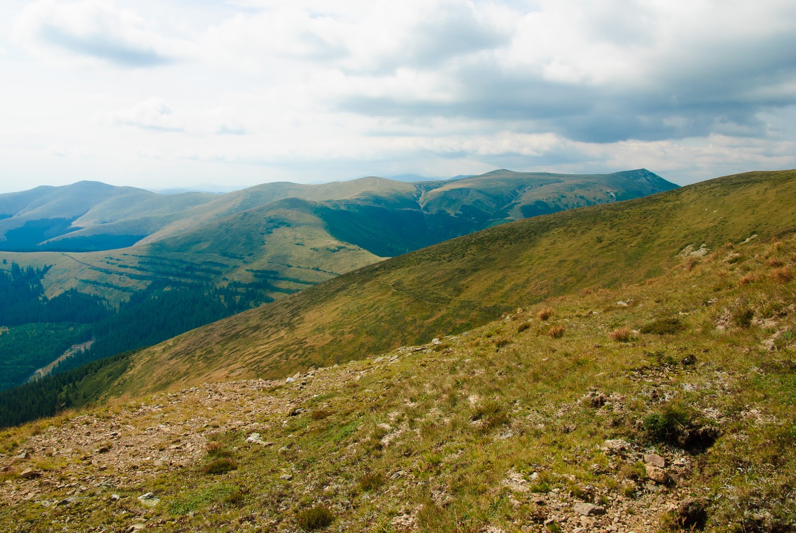
Next day was time for something bigger, highest point of Căpățână mountains, the Ursu peak with an altitude of 2142m promised a good hike for the day.
Actually we were waiting for a more serius hike, but as it turned outm there is a quite good road (recently renovated from EU funds as sign at the entrance says) up to Roman monastery at about 1700m level. Starting from Horezu, the road is well indicated, first to Romanii de Jos, and then at every intersection you can find directions toward Roman monastery. A good gravel road takes to the plateau, where a lot of activity waits, recently built weekend houses, rescue stations, hotel/restaurants hint at a rising tourism activity in the area. I wouldn't be surprised if a ski resort would open soon there.
Anyway once on the plateau, the road continues towards the main ridgeline, so we also followed it to about 1800m ASL, when a big bog on the road stopped us. It looked quite deep, so I didn't want to try it with my car
so from there we continued on foot.
Obviously not everyone was so worried as myself, we met quite a lot of traffic:
And also quite soon we found out why the good road up the mountain:
I don't want to insinuate anything, but we didn't so any tree at this altitude and anywhere above us.
But beside these, a much more peaceful sight waited in the alpine region:
and of course a lot of cowberries for us to graze :)
After arriving to the main ridgeline of the mountain, the road we were following so far turned to the right, while the summit was to the left, so we had to switch to a much less used road
taking us close to the summit. That road also takes a bit below the summit, so the last 50m is plain climbing between rocks
The summit has a summit-stone and some big rocks piled up, so it's a good place to put up the antenna. However my antenna which was mildly underperforming the day before, gave up this time, and the backup antenna wasn't in good shape either, not to mention the propagation, so after a few QSOs (barely enough to qualify the summit) I had to give up.
Especially that we wanted to bag another summit for the day, so continued our hike towards the next peak to the west: Nedeia. However after about an hour of hike we met an indicator saying Nedeia is another 3 hour hike, and we could also see in the far distant, that it is indeed a serious hike to there
so we decided to turn back, and get down from the mountain in the daylight. Already in the autumn the day is short so we couldn't get back in light if tried for Nedeia. Perhaps in the summer.

But to not end the day without a second summit, after getting down to Horezu, we have stopped to activate the small hill of Slatiaru, which we thought would be easy enough even in the dark. Well as it turned out, it was much harder than the 2000 m summit before. It was only about 180m climb on a hill covered with forest, but the slope was sometimes near vertical, with some cliff on either side, so it was a sweaty peak, and of course in the dark. But at least some points bagged in here also.
And the last points for this area, as tired from the day hike, and also road home ahead of us, we decided to postpone the summiting of the Buila-Vânturarița for some other time, with longer daylight and better WX conditions.


2014. augusztus 18.

Sidenote to the YO SOTA marathon 2014

The last week took place a very nice initiative of Sorin, YO2MSB, the YO SOTA Marathon, a full week of SOTA trip in the highest mountain ranges of Romania. Many amateurs responded to Sorin's call so a team of YO2BP, YO9IRF and YO8SEP joined him on this tour. Unfortunately I already had may two week vacation before, and had to be at work so I had to skip the tour (will not make this mistake next year) and I could only join the guys for the last day of the trip.
But before going on with the events of that last day, if you are interested by the full story, here are some links:
http://yo9irf.blogspot.ro/2014/08/sota-tour-yo-2014-part-i.html
http://yo9irf.blogspot.ro/2014/08/sota-tour-yo-2014-part-ii.html
http://yo9irf.blogspot.ro/2014/08/sota-tour-yo-2014-part-iii.html
http://radioclubulromaniei.ro/maratonul-sota-2014-2/ (in Romanian)

So back to my journey. The marathon as planned by Sorin ended on Friday with 2 summits near Brassó, YO/EC-011 and YO/EC-428, both being already activated by me, they are sort of local summits. I managed to get off for the day, so I had two options: join the team on their activation or go to another nearby summit and have some s2s with them. After some thinking I decided to have both: so while they are activating YO/EC-011, I go to another nearby summit, Hoapecu, YO/EC-367 (which wasn't so far activated) and then join the team on YO/EC-428.
So early morning I set out to the village of Holbav, west of Brassó, just under Hoapecu. Parked the car near a playground just after entering Holbav, to the left of the main road. A forest road starts from that intersection, which as it turned out takes right to the Hoapecu peak. Unfortunately mapping is close to nonexistent in the area, so here is my track to the peak and back:
As you know me, I like to explore the area I'm activating, hence the two trails to the summit, the purple one is I took going up to the summit, as I said it starts next to the entry into the village (eastern part) and follows a forest road, actually a quite good road, used by horse carriages and perhaps 4x4 vehicles. The slope is quite gentle, it goes by on a ridgeline with a small portion of about 2 serpent curves in the middle of the forest.
The summit is about 40 minutes of walk, mostly in forest, but the last part is a large clearing with a great panorama to the south, with cottages spread out on the hills around:
It is a nice quiet place to retreat from the rush of the 21st century.
The summit is again covered with forest, but just next to the road, there is a narrow clearing, enough to erect an antenna and to have some clean takeoff angle:
So I quickly set up, made myself comfortable and started to look out for the guys on the SOTA trip to check whether they arrived to the summit or not. Well after some shouting on 2m FM, finally managed to have a chat with them, and it turned out they just barely woke up from last night's party, so it was still lot of time to waste until they will get to their summit. Well at least the weather even though looking ugly was still acceptable, no immediate sign of rain, so I started CQing for SOTA, and this time had a lot of time to answer any calls (remember my last two weeks of rushing through summits and complaining about not able to work everyone waiting for me, well this time I made up for that).
I operated about 3 hours on the summit with great success, and finally I made also s2s contact with YO2MSB and YO9IRF (it turned out that YO8SEP took off earlier, and did not join them for the last day), after that left them with my operating frequency and started to pack, to have enough time to meet them outside Brassó for the last summit of the day.
For going back I took another route, it was actually following the road I was coming up, which continued the other side of the summit (marked with green on the map above). This route offered a nice view of the village Holbav:
you can see the upper part of the village, where I left the car and the lower part, where my route entered. This also meant that after descending a lot more then the route up, I also had to climb back to the car. Overall this route is the harder I think, there is also a very large portion of a steep slope and the total height difference is bigger also. Even if it looks a bit shorter it took more time to descend than it took the climbing.

After getting to the car, I rushed back to the city to meet the marathon team. They also finished in the meantime their activation and was en-route to YO/EC-428. I met them in Szentpéter village, north of Brassó. We had a small chat there, after that YO9IRF, who was already tired of the whole week activation took off towards home, and left me and Sorin to climb the summit and activate it.
A nice short hiking followed, it was already a familiar place for me, but Sorin was very excited on the area, after a full week of bare alpine adventure, a nice clean forest reservation must have been a real refreshing experience.
Here is YO2MSB at the mike:

Overall a nice experience I think, and I definitely have to join them next year.

2014. augusztus 11.

Away for a while

Just got back from 2 very long weeks in hiking camps around Transylvania, not much to say SOTA related, we were on organized hikes, but whenever we touched a summit, I did manage a few minutes for some QSOs as well. I'm not really fond of doing quick activations with just a few QSO to qualify and then fleeing the summit, but sometimes the circumstances are just that, weather is capricious, technology can play jokes sometimes (already happened to me as well) and if hiking in large group they tend to become anxious after a while. I did try to make as many QSO as possible in the given timeframe, but I must apologize to anyone left without a contact. There will be another chance and hopefully much better circumstance.
This time I will not write a journal of every activation I made, just some photo albums of those two weeks at the usual place here and here.
One summit I must still emphasize as it is very special to me and my people as it is actually named the Székely Rock, near Torockó, and is one of those mountains which does need to be climbed at some point in our life. So I also made arrangements to climb it myself, outside the usual program so I did have several hours on top for QSOs.
Again the usual photos on the link above, but here is one more time the mountain:
from sideways it does look like a sleeping giant Székely warrior, who after freeing the people of Torockó from the tartars, had laid down beside the city protecting them from further invasion.

2014. június 29.

Another route to Gropșoare

After Răzvan, YO9IRF successfully activated YO/EC-057 having also a very nice report about it, it was time for me to do a little climbing exercise and conquer the summit.
So in what looked a nice Sunday, together with friends Mihai and Sorin, we set out for a little hike to Gropșoare. To make things little more interesting we didn't used the easier track via Muntele Roșu as described by Răzvan, but decided to take from the other side of the mountain, from Poiana Valea Stânii, a small resort in the Telejenel valley.
Valea Stânii is accessible by car from the DN1A road from just outside the city of Cheia, the road is not excellent but doable in a bit more solid cars, in the first part it serpent in the forest climbing a small hill before descending to the Telejenel valley. This portion has some breaks along it due to torrents, so care should be taken. After meeting the Telejenel, the road becomes much better in shape, and also some weekend houses start to turn up. Finally at a large glade we arrive to the starting point of the track, actually it is a meeting point of at least 4 marked tracks, so the place is quite large and well indicated.
Even some horses were there waiting to make friends with them:
Across the glade the Gropșoare - Zăganu massif is rising above us:
unfortunately that is not the peak we are target, it only shows the valley (Sterp) we will follow to reach the ridgeline, the summit is much behind those in front. The valley is in the crack between the two peaks in the photo.
The trail is very well marked with blue triangle on almost every other tree along the path, it must have been repainted very recently:
 In the first part it goes in a dense forest, starting slowly
but soon it turns very steep, and keeps on for a good while, so we already spit out our lungs when finally reached the alpine region:
from here the trail joins in with the red cross coming along the ridgeline from Cheia. Of course some more climbing (this time on exposed rocks) awaits:
but after climbing the first peak, we can have a glance on the Gropșoare peak, it's the one on the background:
So some more hiking is needed, and we didn't got rid of rockclimbing yet, there is some portion of the trail where some via ferrata is also needed
not to soliciting though so in a little more than half an hour since reaching the ridgeline (and after about 3 hours hiking from down the glade) we were finally up on the peak, admiring... well admiring nothing because of the big cloud all around us.
Time for a little SOTA
however propagation was also quite terrible, and after about 9 QSOs in 45 minutes, and the team already getting cold it was time move along.
We continued the path along the ridge so that we can get down in the Alb valley (yellow triangle) on the northern side of the mountain (it also gets to Valea Stânii, which is as I mentioned earlier is an intersection of multiple trails).
After descending about 15 minutes, before leaving the ridgeline, the cloud cover already raised so that we could have a beautiful view towards the Ciucaș peak
another SOTA summit I really need to do sometimes soon.
Of course when we arrived down to the car, all the clouds were gone, and we had a beautiful sunshine afternoon, this is the usual luck.

2014. június 14.

YO/EC-107

Another summit without any trail on the last ascent, Tesla (no connection to the great inventor, although probably the name has some Slavic origin) is one eye-catching hill emerging from the lowland west of the Csukás mountains. Having a shape of a dome it is an easily recognizable feature even from the distant road below:
Tesla in the background
Being near the Csukás mountain, it is also a popular tourist destination, either in the way up to Csukás or just by itself, most easily accesible from Babarunca resort following the red stripe trail.
Together with YO6HXO we started out the conquer this piece of nature wonder in a nice sunny morning:
Start of the trail in the early morning
Unfortunately the right after this nice clear path section we just missed somehow the sign, which at a hardly visible point goes to the left, and the big clear path continues forward a few hundred meters, however after that it brutally ends, and we found ourselves in the middle of the forest without any path in forth. Now the wise choice would have been to turn back and find the marked trail, however, the forest didn't look that bad and we decided to go forward uphill, and at some point we will certainly cross the trail again. Big mistake. Unfortunately in the upper region was some serious wood-cutting, and although it was not a clearcutting, but a well arranged rarefaction, they left all the small branches and thin trunks on the ground, making the movement ahead a pain in the ass. It took us at least an hour wasted until we made it trough and back to the marked trail. So be careful and watch those markings.
After reaching the ridge, the trail joins with the red cross marking coming from the left and continuing towards the Tesla Glade, a very large clearing between the Tesla and a Csukás mountain, with beautiful view to both. From the clearing the dome of Tesla is rising out with menacing looking rocks:
Tesla from right below
The thing is that as I mentioned earlier, Tesla is also a popular tourist destination, 3 more marked trails are meeting us here coming from all other directions, however, actual the glade is the tourist destination, where everybody can admire the magnificent wall, but that's it. There is no trail up to the summit, nothing. But well, SOTA is SOTA, it's about going to summits, so we did go looking for a way up there. And found a possible entry: at the northern face, following the blue cross trail, near the end of the Glade, there is a smaller narrow clearing to the left leading to a pretty clear forest covering the northern face of Tesla. The terrain there is not so rocky, and we were able to follow some animal trails between the ravines up to the higher regions. They were left definitely by some larger animals, but fortunately we didn't met them, and smaller and nicer creatures:
A scared hedgehog, wasn't really used to humans in this area
After a heavy ascent (it isn't cliffhanging but still it is very steep) arrived on the flatter portion of the summit, and well in the activation zone, we could started looking out for a good place for the shack. It actually didn't need too much looking, there where plenty of fallen logs to sit down:
CQ SOTA
and also smaller tree trunks to fix the antenna to:
Shack on YO/EC-107
After about an hour of operating it was time to bring down the equipment and head down in the hope to also activate YO/EC-153. Unfortunately back down in glade, exiting the forest we realized that the very nice weather we left, turned into a very ugly covered sky, with a thunderstorm closing in. We still continued a bit our hike along the blue cross, however not long after the thunderstorm was very clearly near us, above the Csukás:
Ugly clouds
and the lightnings around us led to the decision to postpone the activation of YO/EC-153 and get down fast from the mountain. So maybe next time we will have better luck.
Here is the track with red marking the way up to Tesla (including the bushwalking everyone should avoid, and the the path up to the summit from the edge of the glade) and magenta the road down we took after realizing that the weather is not on our side:

2014. június 9.

YO/EC-349 Nagy-Somlyó

Pünkösd előtti napon, a Nagy-Somlyó és a Kis-Somlyó közötti nyeregben, több-százezer hívő, mi lehet az? Természetesen a csíksomlyói búcsú, amibe most azért annyira nem mennék bele, viszont pünkösd másnapján ugyanolyan szabadnap viszont sokkal nyugisabb a helyzet és kiváló alkalom a Nagy-Somlyó aktiválására.
A csúcs a maga 1033m-ével messziről kivehetően magasodik Csíkszereda felé, hívogatva az embert egy kis rádiózásra.

A túrát a legcélszerűbb a csíksomlyói templom előtti parkolóban kezdeni, fel lehet ugyan menni autóval is a nyeregbe, de az azért mégsem olyan szép. A nyeregig a rengeteg kitaposott út (főleg a búcsú után) közül választhatunk, nekem persze mint világ lustájának a legkényemelmesebb kerülő jön be egészen a nyeregig. A nyereg előtt letér róle egy piros pont jelzés ami szintén a csúcsra megy, de jó nagy kerülővel, gyakorlatilag átmegy a hegy háta mögé, na az viszont már sok.

Úgyhogy fel a nyeregbe, ahogy sokan mások is, meg lehet csodálni a kápolnát:


aztán onnan toronyiránt neki a csúcsnak. Ez az út is jól ki van taposva végig széles ösvény visz majdnem egyenesen felfelé, persze azért az emberből kiveszi egy cseppet a szuszt, mert azért szintkülönbség van elég.

Fenn a csúcson egy hatalmas kilátó-torony fogad, amire a ráakasztott tábla szerint tilos felmászni, de egyébként is elég durva érzés azért. Meg persze utoljára úgy volt megtákolva, hogy én már a szupervékony alakommal nemigen férek át az utolsó fellépőn. Na de ez van.
Rádiózni viszont elég körülményes, mert ugyan a kilátó az jól kilóg az erdőből, de az alja biza nagyon be van nőve, és hatalmas csihány-bozótok terülnek el körülötte. Szerencsére azért az ösvény környékén van annyi hely, hogy egy antennát kihúzzunk és kényelmesen rádiózgassunk, csak épp ügyelni kell a látogatókra, nehogy belefussanak az antennába.

Sajnos jó szokásom szerint úgy belemerültem a rádiózásba, illetve amikor az idő hirtelen rosszra fordult (ez utóbbi vajon miért nem lep meg) a bontásba és seprésbe lefelé, hogy megint elfelejtettem csúcsfotókat készíteni. De legalább itt van az útvonal fel a csúcsig (sötétzölddel van az általam bejárt útvonal a parkolótól a csúcsig, pirossal még látható a jelzett ösvény is, illetve a nyeregig tartó megannyi ösvény is fel van tüntetve a térképen):


2014. május 25.

HEKE tábor Katrosán

Ezen a hétvégén került sor a háromszéki EKE idei megyei táborára, ezúttal a GÁMOK EVITA nevű táborában. Persze nagyon jó móka volt, van is itt néhány kép. Volt benne túrázás, tokányolás, jó kedv, jó idő, rossz idő minden ami kell.
De most nem is nagyon térek ki erre, hanem a túráról szólnék néhány szót mert hát a rádiózás sem maradhatott el. Két túra volt a táborból: egyik a Gombás-bércre, másik a borvíz-forrásokhoz, és hát bármennyire is szeretem a borvizet, a Gombás-bérc az SOTA csúcs (na jó némi nyakatekeréssel, de erről majd később) így hát egyértelmű volt a választás.
Persze nem lett volna EKE-túra, ha a legkönnyebb útvonalon megyünk, ezért egy alternatív útvonalat javasolt a túravezetőnk ami nagyjából a főutat elhagyva (azért volt 3 kilométer gyaloglás az aszfalton is) a gerincen ment végig a megyehatárt követve. Bár az eleje egy kicsit zűrös, főleg az erdőben amíg kiér a gerincre, de aztán fenn a gerincen nagyon látványos az egész.
Végig a gerincen egy jól követhető szekérút is végigvonul, így jelzés hiányában is egyszerű a tájékozodás, később pedig a Katrosából (a kocsma mellől) induló kék pont (nagyon hiányos) is csatlakozik de szinte feleslegesen.
Mindenesetre egy eleg hosszú evickélés után értünk el a csúcsig, vagyis hát majdnem. Mert van egy kis bibi a Gombás-bérccel és a SOTA-val. Maga az egész bérc egy elég hosszú gerincet képez, aminek majdnek a közepén egy kisebb nyeregben halad át az eddig követett szekérút, hogy aztán leereszkedjen Csángótelepre. Ettől délre van egy csúcs tetején egy kereszttel ami egyes térképeken úgy szerepel hogy Gombás-bérc 1199m magassággal (más térképek Pólya tetőnek is hívják) és általában minden turistaút ezt tekinti célpontnak főleg a kereszt miatt. Igen ám de észak felé a gerinc jobban emelkedik és a legmagasabb pontja (megint más térképek szerinti Gombás-bérc) 1214m magasságal egyértelműen a magasabbik és így természetesen a SOTA célpont is. Máskülönben viszont csak egy csupasz nagy kiterjedésű legelő, úgyhogy a kutya se jár arra. Természetesen a csoportunk is a keresztet vette célba és ott állt meg ebédelni, így én még egy kilométert kellett arrébb sétáljak, hogy rádiózhassak (a nyereg jó 40m-t esik, tehát az előbb-utóbb uniformizálódó 25m-es szabály szerint a kereszt kiesik az aktiválási zónából).
Hogy mégjobb legyen a telefonom is vacakolni kezdett, úgyhogy self-spot híjján biza nagyon megszenvedtem a minimális 4 QSOért. A többiek már rég elindultak visszafelé, mire meglett, így aztán rohamtempóban csomagoltam és vettettem utánuk magamat, de szerencsére még mielőtt a jelzés letért volna a gerincről utolértem őket. Pláne, hogy a csapat úgy döntött, jobb minél előbb a sört szopogatni a kocsmában, úgyhogy visszafelé a gerinc helyett a legrövidebb utat választottuk a jelzés mentén.
Végülis elég jól jött ki a dolog és egy fárasztó, de nagyon jó túrával a hátunk mögött zárhattuk a napot. Íme az útvonal: